Ngiyampaa elder Dr Beryl Carmichael says the record flooding on the Darling River near Menindee in New South Wales’ far west, was caused by Queensland holding water to grow canola, sorghum and cotton rather than releasing it downstream.
“They should have been releasing it from the beginning,” Carmichael told Green Left.
Carmichael, who is 87 and has lived her whole life along the Darling River, is waiting out the latest flood in her home on the sand hills of Menindee.
Her home is above the flood waters, near the main railway crossing, but she has fallen in the water outside her home and broken three bones, including a rib. She is managing to move around with her walker.
Carmichael is particularly critical of former Deputy Prime Minister Barnaby Joyce and the Coalition government’s decision to sell water licences on the international water market. This put the control of water into the hands of private investors.
According to AgriInvestor.com, the estimated proportion of water entitlements owned by foreign investors “is most pronounced in the Northern Murray-Darling Basin where foreign-held entitlement is 29.6 percent of the total entitlement on issue”. Canadian corporations are now the single biggest foreign owners of Australian water entitlements.
“I hold Barnaby Joyce responsible,” Carmichael said. “He came out here and wouldn’t talk to the first Nations people, just talked to ‘false’ Barkandji mob and people who agreed to sell off all our rights.”
The Murray-Darling Basin Authority’s new chief executive effectively disbanded its Indigenous advisory group, the Northern Basin Aboriginal Nations (NBAN) organisation, in mid December.
It also ended a $400,000-a-year contract for NBAN’s internal operations and a $1.25 million First Nations cultural flows project officer tasked with the development of a cultural flow plan.
“It’s cruel, what has happened to our water,” Carmichael said. “We can’t even get a licence to grow a vegetable garden now on our own country.
“That’s why I support a Voice to Parliament, because our voice has been lost: we need to be consulted.”
Carmichael grew up on what was once droving country. She said she did her lessons in a wagon on the road. She remembers other floods, the major ones being in the 1940s, 1950s and in 1976, when the river reached the record 10.7 metres.
She remembers too, with great sadness, the terrible drought of 2017–19, when the Menindee Lakes became bone dry, and the massive fish kills in the Lower Darling of late 2018–19.
“Sampling [from] around that time showed there were 98 agricultural chemicals in the water and no one could drink it because of the toxicity.”
As of now “the highway remains open to Broken Hill, but all the properties along the river have been inundated and homes flooded. People are being accommodated in emergency centre and alternate housing in town,” she said.
Carmichael maintains the Ngiyampaa were the region’s first people. They encountered Major Thomas Livingston Mitchell in the early 1800s when he was surveying the Darling River.
“My people suffered extensive massacres and were rounded up onto missions and reserves, until the government water tank, between Ivanhoe and Cobar, went dry and we were trucked out.
“Some were sent to Brewarrinna and some got sent to Menindee: families were split apart … Now our voice has been lost to people making false native title claims to this country.”
Carmichael wrote to the former Queen Elizabeth II in 2021 about her concerns with the Ngiyampaa people’s loss of rights. She was advised to take the matter up with the Governor-General and said she planned to take the plight of her people to King Charles III as soon as she recovers.
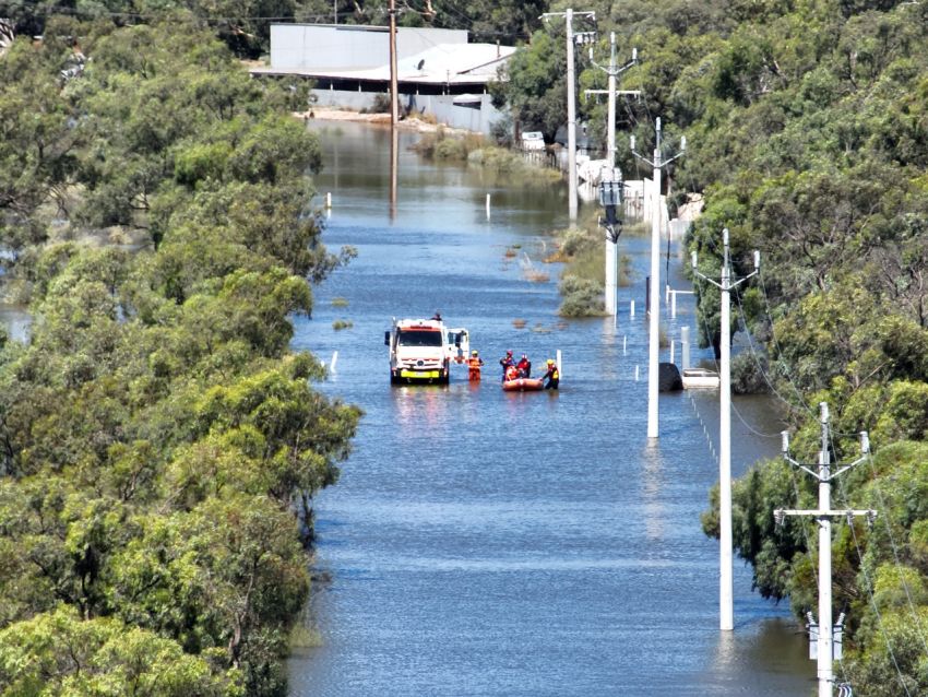
The SES issued an evacuation order for Menindee on January 9, directing residents in the township and low-lying areas to leave as the Darling River was expected to peak at about 10.7m. This is above the 1976 flood record of 10.5m. The ABC reported residents battling the inundation in 38–39°C heat, trying to heighten levees. There was little to no warning given to them.
Between 30 and 35 properties and many more houses along Irrigation Road, McInnes Road, Pooncarie Road and the Wilcannia-Menindee Road are among those that could be worst affected by the water flow.
WaterNSW only opened the Menindee weir gates on January 8 to allow the maximum amount of water to flow further downstream. Seventy five thousand megalitres a day is being released, the equivalent of 30,000 Olympic pools.
Currently, the river height is steady, at about 10.3m, but major flooding, up to 10.7m is still possible over the next week. The SES said water levels are expected to remain above the major flood level (9.7m) at Menindee through to mid January.