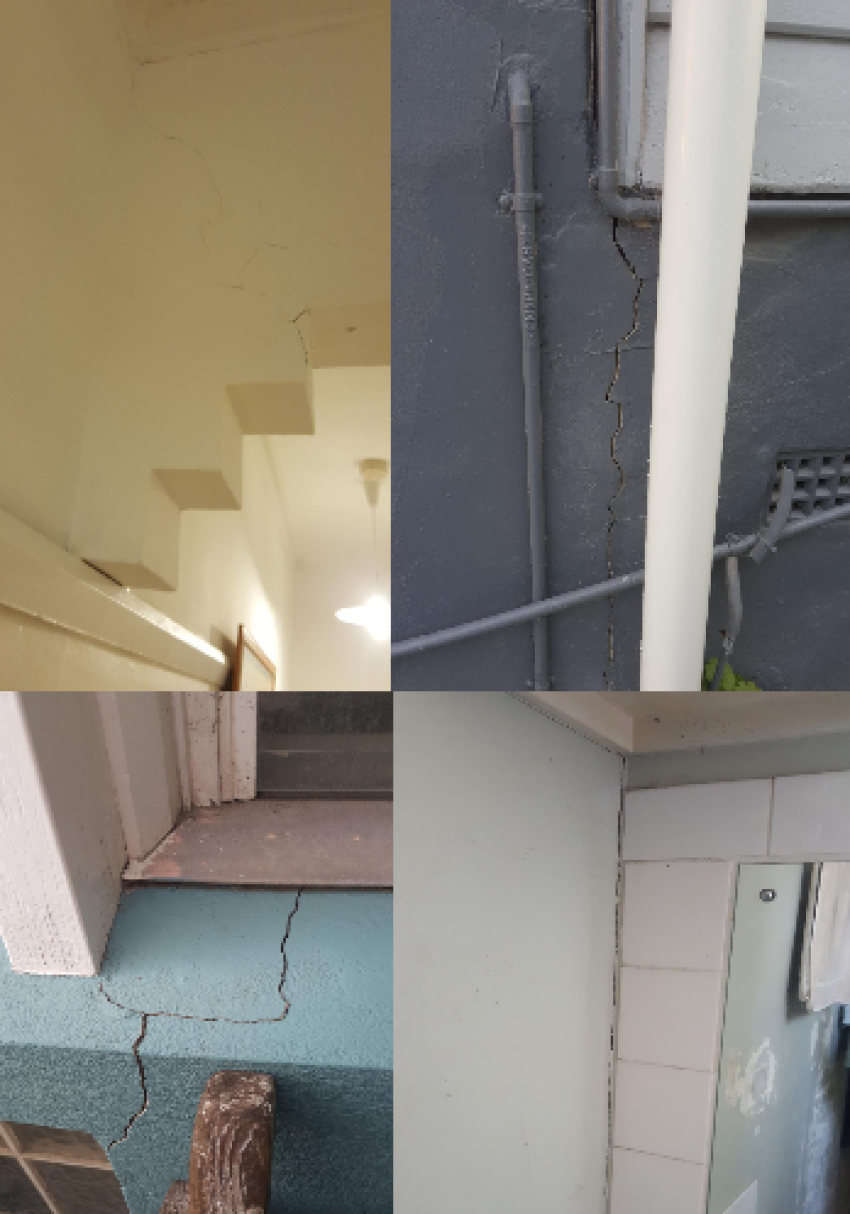
Residents in several Sydney suburbs where the rapidly expanding network of WestConnex roads and tunnels are being built have been complaining that their homes have suffered wall cracks and jamming doors. But they have had little success in getting redress or even acknowledgement from the New South Wales government.
The issue received significant media attention following the temporary evacuation on July 24 of a three-storey block of units in Ashfield, after residents were awakened by ground movements, cracking and popping sounds to find some internal doors were jammed.
Veteran anti-WestConnex campaigner Andrew Chuter then discovered that geotechnical surveys, done before the series of M4 East tunnels were bored beneath the units, had identified the likelihood that those units might experience ground settlement of more than 20 millimetres. This was the exceedance level stipulated in the conditions of approval for the tunnel for buildings of three-storeys of more or buildings with heritage status.
Chuter also noticed that WestConnex had decided not to take mitigation measures because it expected any such settlement to be “uniform”, not uneven.
Since then, residents in Haberfield, where further tunnelling is proceeding, have been told they should not worry about expected ground settlement arising from “water drawdown” around Hawthorn Canal (which the tunnels pass beneath) because such settlement will be “uniform”. Residents do not feel assured by this information.
Green Left spoke to Krish Patel from Sat-Scan, the Australian-based processor of satellite data imagery.
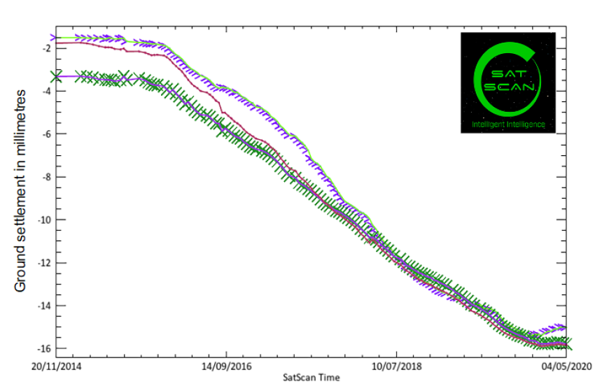
After the Ashfield unit temporary evacuation took place a few weeks ago, the NSW government was quick to dismiss any connection with the WestConnex M4 East tunnels that pass under those units. NSW Transport claimed that it had studied satellite imagery over a nine-year period and did not see any settlement outside the normal range. What does your satellite imaging show?
We have generated four different models which all show movement of several millimetres. Historical data shows that before the tunnelling we were looking at less than 1 millimetre of movement for the 12 months prior to the start of the tunnelling in early 2016.
Once tunnelling has started, we have between 7-14 millimetres of movement until May. There is variation in the speed and timing of the movement between the 4 models. We do not know WestConnex’s definition of “Normal Range” thus we can’t say if we are in it.
What is the degree of accuracy of satellite imaging in measuring ground movements? Does it measure horizontal as well as vertical movements?
The technology is capable of measuring both horizontal and vertical movement up to millimetre level of movement. We have collected data specifically for vertical movement, for millimetre movement. Various between models exist for total movement and velocity. By comparing multiple models, in our opinion, there is movement.
Are there other areas on the route of the M4 East, the partially excavated M4-M5 and the M8 that shows a change in patterns of ground movement?
From our satellite imaging data, we can clearly see movement over the entire length of the M4 tunnelling project. For the M8, we can see movement with high confidence, but have not undertaken a detailed analysis on the area yet.
To date, there is a lot of movement we have detected over Tempe and St Peters. The region has a large area of land with movement.
If such changes are visible, are they associated with intersections of the tunnels with water courses (such as creeks or canals), other infrastructure or areas with a longer history of ground movement?
This is really a case by case basis, because we need to look at the underlying geology. When tunnelling, the first task is to pump the water out of the aquifer before the tunnel starts. This can cause sinking across the whole aquifer and land features, such as creek and canals, also play a significant role in determining what is going on. If a building is on soft ground, sand for example, you are more likely to slide towards the river. It is a very complex question with no simple answer.